OPUS Model Construction
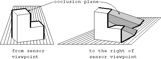
An OPUS (Object Plus Unseen Space) model is a CAD-type boundary
description. Any data for visible portions of the object are modeled
by real surfaces. Any portions of the object not visible are
modeled by occlusion surfaces, representing the maximum possible
extent of the as-yet-unseen portion of the object.
Motivation
In the coming virtual universe, where's all the 3D structural data going
to come from? The traditional method is to construct (program) objects
and worlds by hand. This work strives towards methods to automatically
construct models from image data. For instance, you could walk through
your home with a camera, snapping images, feed the images into the
model builder, and presto! Virtual reality representation of your home.
Related publications
``Extracting a Valid Boundary Representation from a Segmented Range Image'',
IEEE Trans. on Pattern Analysis & Machine Intelligence, Vol. 17 (9),
September 1995, pp. 920-924.
``Building a valid boundary representation from a segmented range image'',
University of South Florida, Dept. of Computer
Science & Engineering technical report #94-01, 30 pages.
C code
A
tar file containing C code which constructs OPUS models from range
images, as reported in the publications above, and as demonstrated below.
Examples
Click on any image icon to download the OPUS model in
VRML v1.0 format .
Occlusion surfaces are shaded in bright greens. Glue surfaces (an
artifact of model construction process, usually extremely small) are
shaded in bright reds. The bottom of the OPUS model is shaded brown.
Real surfaces use all other colors. Please note that
VRML is a
developing language, not intended for solid modeling. Webspace will
view these models correctly.
 back to the
Island Vision Group at USF home page
back to the
Island Vision Group at USF home page
The OPUS model / USF / hoover@bigpine.csee.usf.edu