Photographs by Scott Campbell |
|
||
| Photography appeals to me because it
requires equal measures of technical skill and artistic interpretation. One of its
most enjoyable aspects is that it allows one to use a variety of tools and techniques to
capture an image that is visualized in the mind's eye, even if it is not a literal
translation of reality.
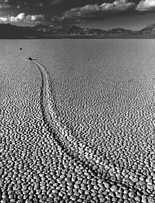
Mystery Rock Trail, Death Valley, 1994 In Death Valley National Park, at the end of a very long dirt road, is a dried mud flat called the Race Track. One can find trails such as this one which wind through the dried mud and have a rock at the end. It is believed that the trail is caused by the rock moving over the mud but the exact mechanism is unknown. Part of the difficulty in pinning it down is that the relative inaccessibility of the place, combined with the conditions believed to favor rock movement (storms, cold, high wind), make observation difficult. Beyond the rock at the head of this trail (small black speck to its upper left) is another rock. It would have been a better picture if this had been moved out of the way. However, there was a note on it saying it was part of a scientific study tracing rock movements so I left it in place. Science wins out over art in this case.
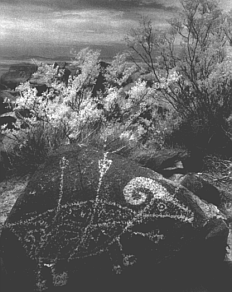
Petroglyphs, New Mexico, 1997 This photograph was taken at the Three Rivers Petroglyph site in central New Mexico. It is located only a short distance from the Trinity site where the first atomic bomb was tested. Many petroglyphs fade with time but these will stick around for a while. As the result of a volcanic eruption, the light colored boulders were covered with a dark, hard deposit. Native Americans later discovered that they could carve away the deposit to form permanent light-on-dark drawings. This is another example of how early civilizations made practical use of something created by nature.
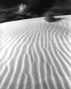
White Sands, New Mexico, 1997 White Sands National Monument consists of a huge area of sand dunes near Alamagordo, New Mexico. It is an other-worldly place made even more incongruous by its proximity to a missile testing range. Some days, White Sands National Monument is closed without warning because of military tests - so your schedule has to be a little flexible if you go there. The sand blows over the roads (they have to be plowed) and this, coupled with the dunes, almost makes you think you are in a snow storm. Then you get out of the car and it's 100 degrees. There are several places in the Southwest where large dunes can be found in isolated pockets - usually it is a combination of wind patterns and proximity to surrounding mountains that keep the sand in a stable location. On a local level though, they are quite unstable with dunes growing and dying on a daily time scale.
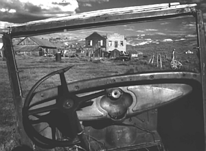
Bodie, California, 1993. Bodie is one of the best preserved Ghost Towns in the United States. Located on the California-Nevada border, it was born in the gold rush of the 19th century and died in a fire during the great depression. However, over 200 structures still stand and it is now a state historical park maintained in a condition of "arrested decay". This means that they try to keep the town in its current state (i.e. keep the remaining walls standing and the metal from rusting further) without restoration. This is harder than it sounds and is an engineering problem if there ever was one.
|
Engineers sometimes are criticized for
emphasizing function over form. However, most engineers I know have a strong
appreciation of art. They realize that an appreciation of the scientific and/or
engineering principles behind a subject does not detract from its beauty. Here are
some examples.
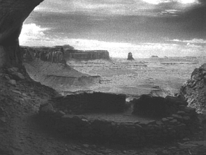
Kiva, Canyonlands National Park, 1996 This is one of my favorite places ever. This kiva is at the end of a fairly long hike and does not appear on park maps. There is a steep climb up to the kiva from the trail. Once you are there (and the probability is almost certain that you will be alone) it is as if you are looking out over a deserted world. Native Americans in this part of the country built their communities in caves and cavities which were cut in sandstone by the action of wind and water. Almost always, they picked locations that had southern exposure - to get sun inside in the winter and to keep it out in the summer. A simple example of how ancient civilizations used natural phenomena to their benefit.
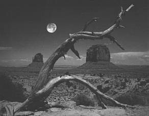
Monument Valley, 1992 To me, Monument Valley (a Navajo Tribal Park on the Arizona-Utah border) is one of the most beautiful places in the country. Many western films (as early as Stagecoach and as recent as Back to the Future III) have been shot here and you are sure to recognize many of the formations. We are used to thinking of mountains as being pushed up from ground level. However, the tops of these buttes were ground level - it was the ground around them that eroded and fell away.
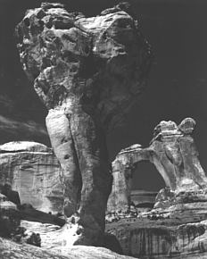
Molar Rock and Angel Arch, Canyonlands National Park, 1996 Canyonlands National Park is one of the best parks if you like isolation. This seems odd to me, being that it is so close to Arches National Park which does draw large crowds. This formation is at the end of a long jeep road that is often flooded. Some people in an Explorer identical to ours got stuck in a wash and it cost them big bucks to get out. We had better luck. These formations last for a long time on a human time scale but not so long on a geographic scale. They are carved by wind and precipitation and will eventually disappear. Several years ago a large chunk fell from the top of Landscape Arch, a famous arch in Arches National Park. Apparently, visitors have been asking rangers what they are going to do to fix the problem.........
Click here to return Home
|
||